 AeroTopoL
Mission Planning & Flight Management
for aerial cameras, lidar, scanners & multi-sensor systems
New!
-
Mission cost evaluation module
-
Enhanced oblique planning for OIS S/M/XL
-
Track-up display on moving map
-
New interface for Flir thermal multi-sensor camera (OTS)
-
Improved trouble-free installation
Tried & tested!
-
User-friendly wizard
-
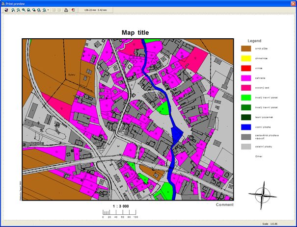
GIS-based mission planning
-
Vector and raster operations
-
River & meta projects
-
DTM adjustment
-
Analysis for placing GCPs
-
Accuracy computation
-
Avionic instrumentation
-
Moving map
-
Interaction with AeroStab
-
Scanner missions
TopoL GIS
Multi-operational topological software
Unique features:- Topology in real time
- Analytical functions
- Complex data processing
- Vector and raster
- No conversions
- Employed in public admin, forestry, agriculture etc.
- Google Earth-able
- Supports most common database systems
- Enables direct connection with GNSS devices
- Spatial analysis of graphic and attribute data
- User-friendly GUI
- Download Topol Explorer for viewing data
TopoL GIS can process both vector and raster data equally well and provide wide scale of vector and raster data manipulation and analysing methods. This functionality includes vector data overlays, database analy-sis as well as image rectification and mosaicking. Main focus in on topology and support for topographic structures of vector data. Digitizing features of TopoL GIS are easy to use and the system is able to resolve topologic relations in real-time while data is digitised. TopoL GIS can import and export data in many industry standard formats running on standard PCs in MS Windows environment. It is available in the following languages: Czech, English, German, Italian, Spanish and Russian.
PhoTopoL
 A powerful application to process photogrammetric and GIS data. It includes the modules for aerial triangulation, stereo editing, orthophoto rectification and mosaicking with color balancing.
Atlas DMT
 An efficient software for processing digital terrain models.
AgiSoft Photogrammetry
PhotoScan is a stand-alone software that performs photogrammetricprocessing of digital images and generats 3D spatial data.
Bingo
 Bingo is a great program for bundle adjustment. It includes full camera calibration,
oblique and combined adjustment, close range and much more.


